M30T Thermal IR Stitiching

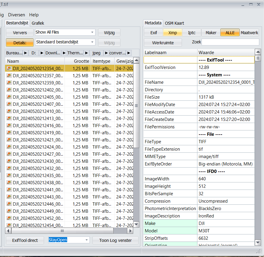
Hello, I am trying to process thermal photos with the radiometric data and using the plant health tab as always. I tried processiing the m30t thermal photos and it is not processing them as radiometric only jpeg. Ive double checked the settings and I get just the jpeg settings.

auto-boundary: true, dem-resolution: 2.0, dsm: true, feature-quality: ultra, orthophoto-resolution: 2.0, pc-quality: ultra, radiometric-calibration: camera, rerun-from: dataset

Hey there! That’s probably happening because DJI uses a proprietery format for embedding the thermal data in the RJPEGs. :slight_smile: :slight_smile:

See other people struggeling:

In this thread I am describing how I convert the images to a ODM-friendly format:

Have a nice day!

1 Like

Any chance I could post a item for this to be fixed with a bounty? if so where can I put it?

Just upload the original image set on a cloud provider of your choice and share the link. If you don’t want to share it to the public you can also DM it to me. :slight_smile: I’ll take a look then.

Integrating the feature of converting the images to .tiff seems kinda hard to do right now, since the conversion is only possible using the proprietary DJI sdk, sadly. No clue how that would work with ODM since it’s open source. Maybe as a plugin? Not sure.

link to the data

1 Like

Can I use this command line on Mac OS?
This is a plugin source code that can be installed into ODM, right? I’m using a Dji Mavic 3T.

Hey there! What command line command are we talking about? In this thread there are only processing parameters posted which you can use in WebODM as task settings.

If we’re speaking about the image conversion, yes the python way I described the second topic here M30T Thermal IR Stitiching - #2 by noro should work just fine if you install all dependencies.

new issue discovered. any fixes?

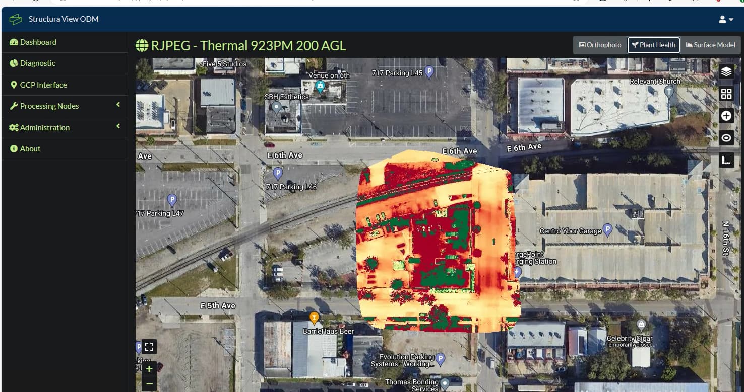
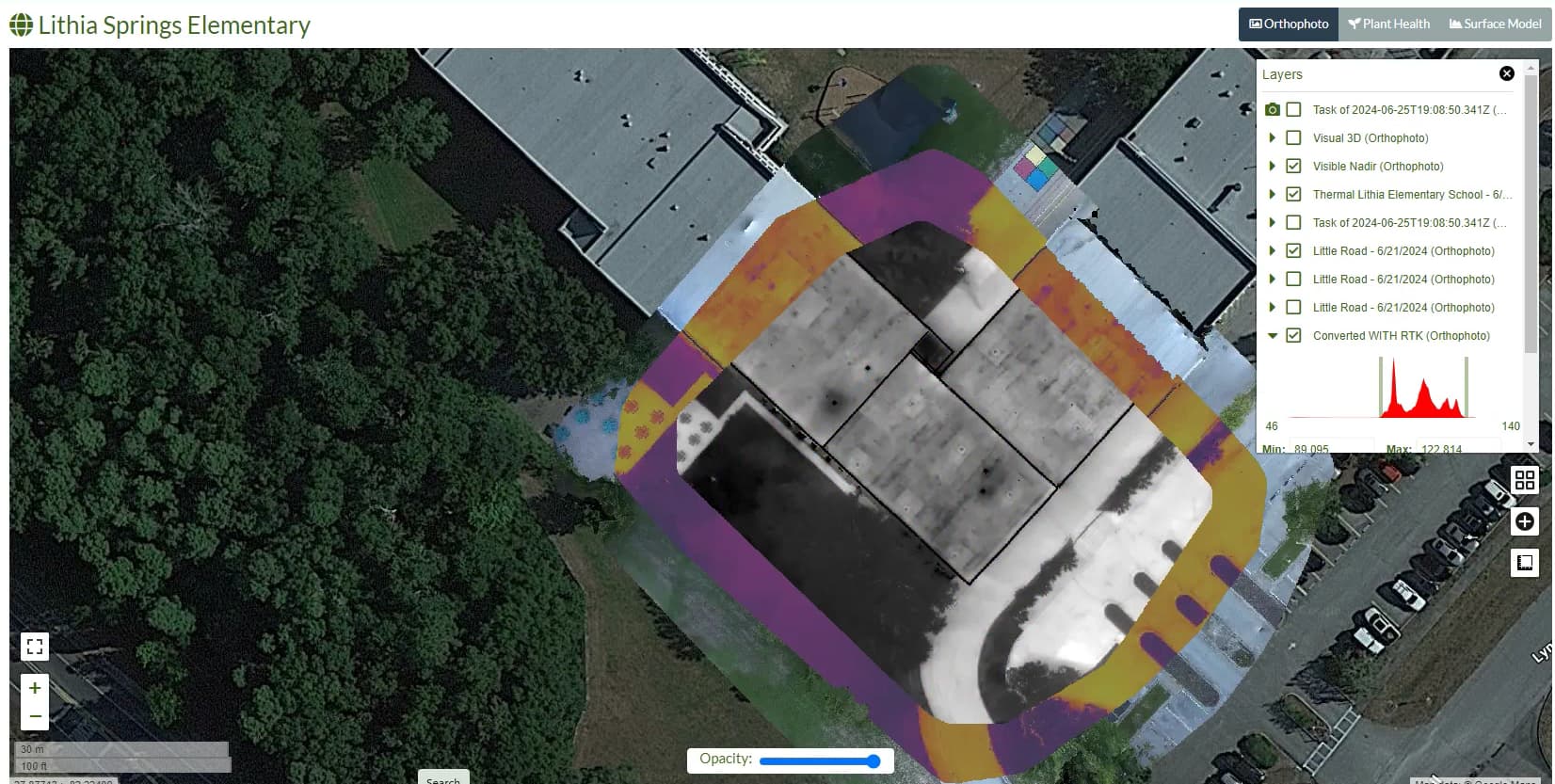
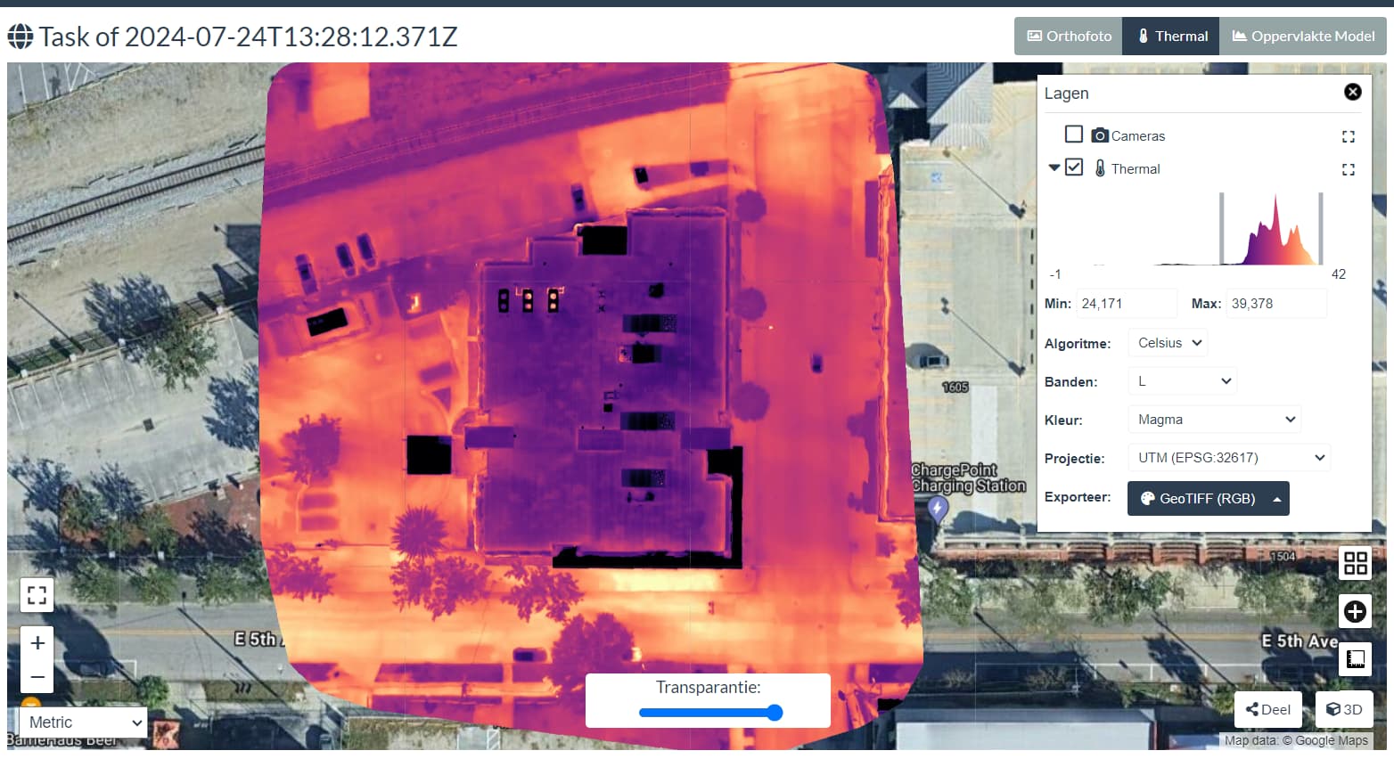
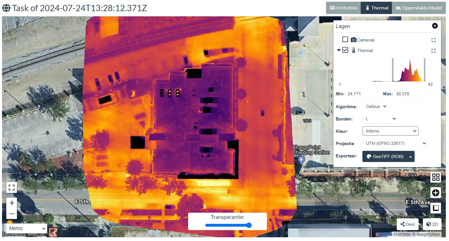
the visible map underneath is lined up perfect along with the raw thermal photos before its converted. the grayscale image is the converted dji rjpeg to the tiff format using the python code. as you can see its a bit off from the orginal photos for some reason. im not sure if its a setting in the program or maybe a projection/conversoin issue from the converstion. i think i can resize it in qgis in post processing but id prefer it display properly lol

as alwys great progress so far. ive also implemnted this pythons script on the back end of my server so if anyone wants to sign on and give me some feed back and test data for the converstion and all the new features im adding to it like aeb merging, raw editing, and odm processing feel free to register!. Veteran Droners

1 Like

Did you see the recent published tool to convert the DJI format to tiff?

Currently not behind my laptop, looking forward to test your set

unfortunately. Same result.

I can’t use it

Check your camera calibration parameters ODM spits out in the report! Compare them. If they’re different try the parameters from the pseudo-color images on the radiometric ones!

Edit: Are you copying the original EXIF-tags onto the .tiff images in the conversion? I guess so, since the tool from Piero also doesn’t resolve the issue. But I figured it’d be worth asking.

Is your (demo)dataset still available?

here ya go.

1 Like

Thanks

I checked the images with DJI Thermal Analysis Tool 3.0, that worked

Next, I converted these images with the Thermal Tools (GitHub - uav4geo/Thermal-Tools: Convert DJI thermal images (RJPEG) into temperature TIFFs for use with WebODM. 🌡)

I started a WebODM task (multispectral) but receive an error.

2024-07-24 13:31:17,321 DEBUG: Undistorting image DJI_20240520212438_0017_T.tif
2024-07-24 13:31:17,325 DEBUG: Undistorting image DJI_20240520212443_0019_T.tif
[WARNING] Cannot extract tags using exiftool: Cannot find Emissivity in tags
[WARNING] Cannot radiometrically calibrate DJI_20240520212435_0016_T.tif: unsupported operand type(s) for /: 'NoneType' and 'float'
2024-07-24 13:31:17,626 DEBUG: Undistorting image DJI_20240520212357_0002_T.tif
[WARNING] Cannot extract tags using exiftool: Cannot find Emissivity in tags
[WARNING] Cannot radiometrically calibrate DJI_20240520212438_0017_T.tif: unsupported operand type(s) for /: 'NoneType' and 'float'
2024-07-24 13:31:17,647 DEBUG: Undistorting image DJI_20240520212516_0031_T.tif
[WARNING] Cannot extract tags using exiftool: Cannot find Emissivity in tags
[WARNING] Cannot extract tags using exiftool: Cannot find Emissivity in tags
[WARNING] Cannot radiometrically calibrate DJI_20240520212419_0010_T.tif: unsupported operand type(s) for /: 'NoneType' and 'float'
2024-07-24 13:31:17,651 DEBUG: Undistorting image DJI_20240520212407_0006_T.tif
[WARNING] Cannot radiometrically calibrate DJI_20240520212449_0021_T.tif: unsupported operand type(s) for /: 'NoneType' and 'float'
2024-07-24 13:31:17,653 DEBUG: Undistorting image DJI_20240520212432_0015_T.tif
[WARNING] Cannot extract tags using exiftool: Cannot find Emissivity in tags
[WARNING] Cannot radiometrically calibrate DJI_20240520212446_0020_T.tif: unsupported operand type(s) for /: 'NoneType' and 'float'
[WARNING] Cannot extract tags using exiftool: Cannot find Emissivity in tags
[WARNING] Cannot extract tags using exiftool: Cannot find Emissivity in tags
[WARNING] Cannot extract tags using exiftool: Cannot find Emissivity in tags
[WARNING] Cannot radiometrically calibrate DJI_20240520212443_0019_T.tif: unsupported operand type(s) for /: 'NoneType' and 'float'
[WARNING] Cannot radiometrically calibrate DJI_20240520212402_0004_T.tif: unsupported operand type(s) for /: 'NoneType' and 'float'
[WARNING] Cannot radiometrically calibrate DJI_20240520212452_0022_T.tif: unsupported operand type(s) for /: 'NoneType' and 'float'

When I analyse the .tif images with ExifToolGUI (didn’t know there was a GUI :-)) I can’t find the Emissivity as well

Maybe @pierotofy can help?

1 Like

Update:

I processed the generated Tiffs in WebODM with the Default setting and that seems to be the trick (first try was as Multispectral that generated the error above).

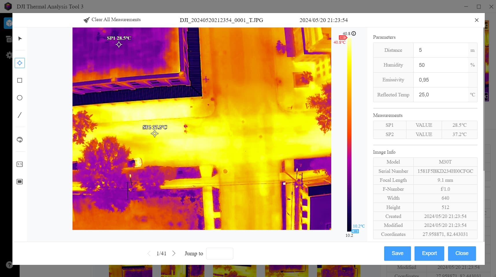
Temp range seems to be like the thermal range in DJI Thermal Analysis Tool

Also other coloring templates

2 Likes

ya the github states that its already calibrated so you dont need to have multi or the camera radiometric calibration selected i the presets. its just processed as regular no radiometric and works . my issue is mostly just the correction of sizing between the rgb and ir images overlayed directly from odm to qgis or even on the potree viewer. its like its shrunk by 5 ish percent compared to the rgb or thermal photos processed in odm as regular jpeg photos.

This topic was automatically closed 30 days after the last reply. New replies are no longer allowed.