New to ODM and having some trouble. I have sucessfully created an ortho map from my XT Dji thermal camera. I cannot seem to do the same with my Mavic 3ET. Tried all kinds of settings. I am not sure what I am doing wrong. Only some of my cameras are being used to create the image. I just am lost. Been working on this for hours. Any ideas? Thanks a million for the help!!
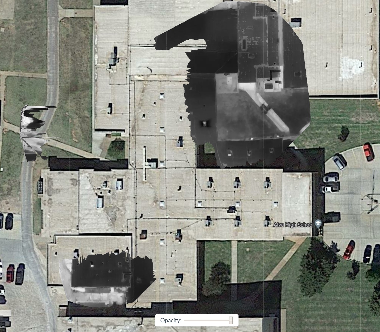
Alva-High-School-7-20-2023-report.pdf (2.2 MB)
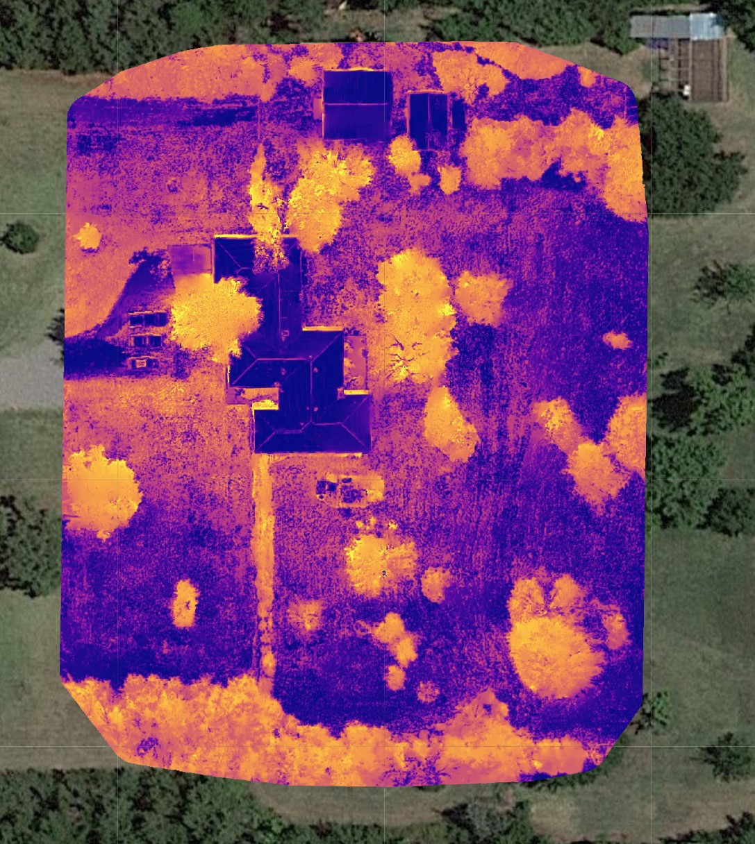
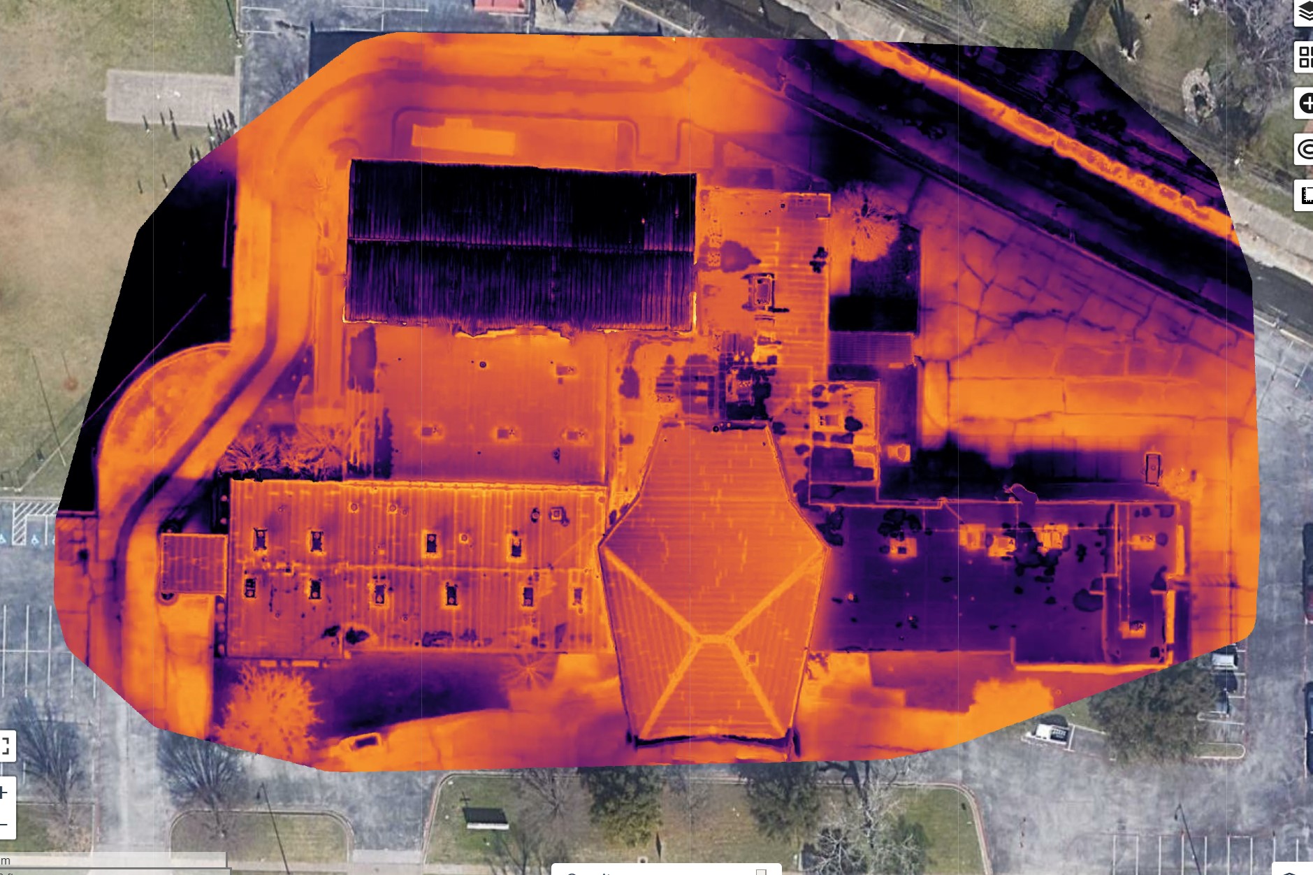
s? Report attached and image of output
Hi Ern,
Can you share your processing logs (report is helpful, thanks!), your flight height, the height of the building, and your overlap? I suspect this issue is lack of overlap on the taller portions of the building based on what I’m seeing in the report.
Welcome to the forum!
Sure thing. Thank you sir!
I flew at 100 ft. Building probable 30ft tall i suspect Overlap was at 55%. I tried using a grid pattern too (i flew this building twice for test purposes)…but that would not process either. Really weird.
task_output.pdf (238.1 KB)
I think you should use a higher overlap, especially with (smaller sensor) thermal cameras. Personally, when flying thermal missions, I use at least 80%
Ok. I can do that. Thanks for the reply Aerat. I am curious why the grid pattern did not process either however. Over 160 images in that space. Strange.
When I processed my XT camera…the files only had about 40% overlap. Not in a grid pattern either. I guess all cases are different though.
Should I not worry about flying in a grid and only fly normal mapping pattern with high overlap like you mentioned?
Without enough overlap, you can get really messy data, as the algorithms don’t have enough information to construct something sensible.
And sometimes, we fly with lower overlap and get lucky! Which is nice, but also confusing, because it isn’t repeatable in the ways we might hope.
Edit:
Also, with buildings, your effective overlap will be much lower.
OK. Good info. So at least 80% like Aeret mentioned? Does it matter if you fly in a grid pattern at all?
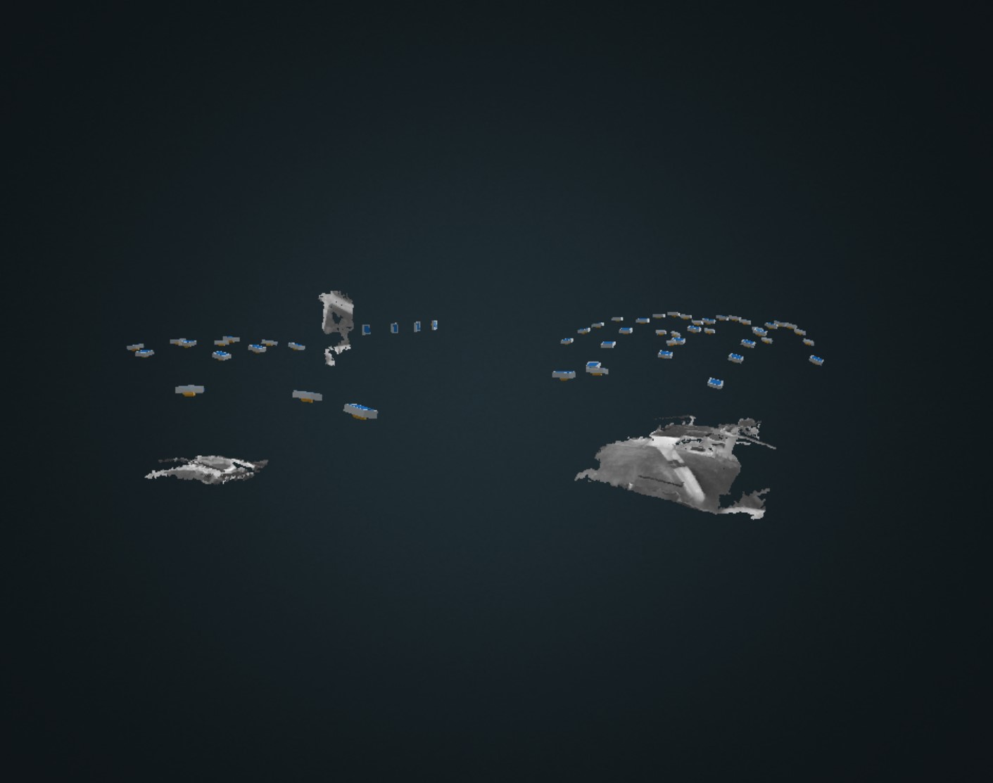
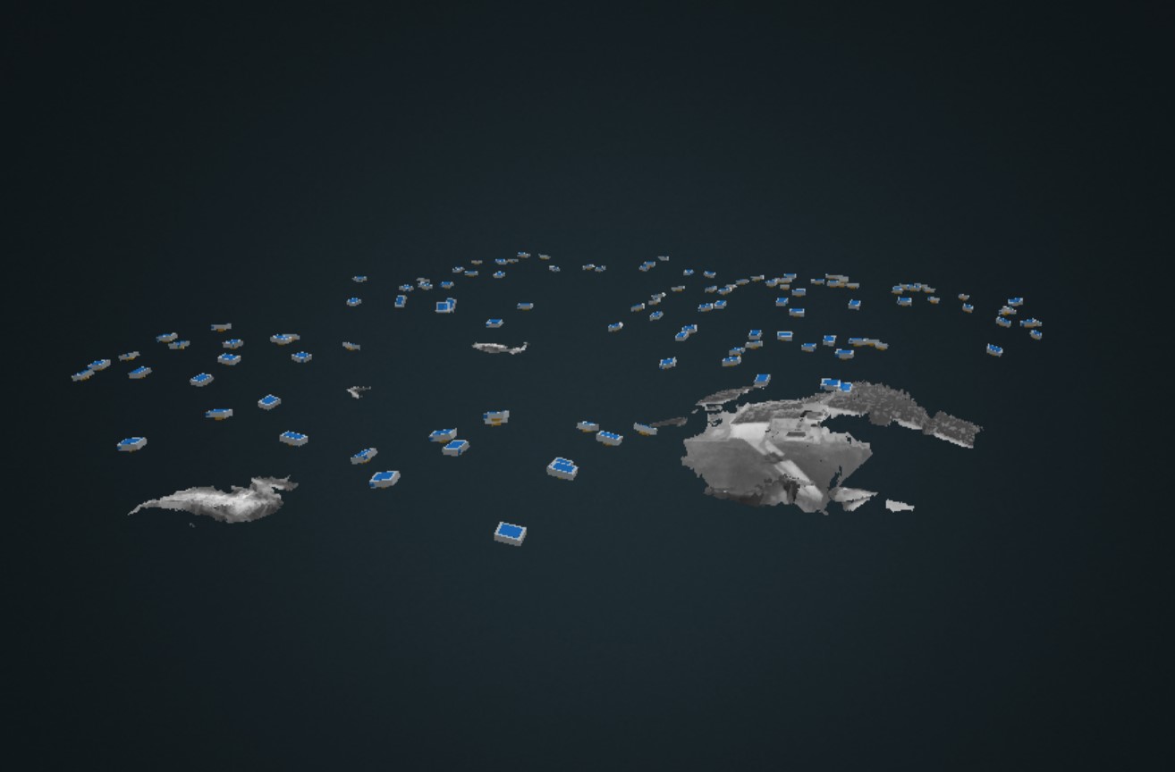
Curious why the cameras are in an arc pattern to (in 3d).
I fly all my mapping missions at 80%, front and side
Sound like the that’s what I need to be doing. Are you flying in a standard pattern or in a Grid? Are you capturing infrared or light images?
Doing more research on this subject…
This is a job I did several years ago using the XT Dji Camera and Inspire 1. Overlap in the 50 range.
I am fine with capturing with higher overlap…but any possibility that the Mavic Infrared camera settings in ODM need to be tweaked in some way as well?
It seems like all my XT Map jobs easily get stitched. The Mavic camera not so much.
I also fly all my maps as a grid, sometimes several at different heights and gimbal angles
If I remember correctly (which I may have the numbers wrong), 52% overlap in a standard grid duplicated as-is to a cross grid is closer to 77% effective overlap. I’ve been curious for a while if flight planners take this into account when specifying overlap or if they are consistent between applications. I wonder if your 50% was closer to 75% effective.
You’re thinking the same thing I am thinking. Leaves me with questions. I feel like this issue has something to do with the thermal camera on my Mavic. All works well with my XT camera…just not the Mavic Thermal camera. And this was not in a grid pattern. Its very odd
Given 50% overlap, it’s more unusual that the XT works than the Mavic doesn’t work. Failing to get reconstructions at low overlap are more normal than successfully getting them.
Indeed it is. I need to figure this out somehow. I am going to get back onsite to recapture the images. I will certainly gather these at 80% overlap. Do you think I would be safe not flying a grid pattern if I capture at 80 overlap? Will just plan to do that if so.
For me it always worked without a grid if you just want an Ortho on 80/80, either Air2s, M3T or M3M. If you need 3d you need a grid and Gimbals at 60-80 on at least one flight.
I think another issue could be that you might had 50 on ground overlapp but the buildings height will take away a lot of overlapp, especially when flying only 100ft high. Imaginet those Buildings are only 30 feet high the Overlapp on top of the buildings will probably be somewhere in the Range between 0-20. Please consider that before the next flight. You can change the Settings to solve this problem with the M3(E/T/M). Some Settings, i just know the German one, in Englsih probably called something like “height diffrence between object to capture and starting point”