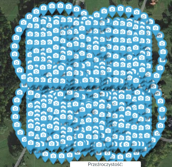
Hi! I have 4 image datasets of bigger area. Each dataset was separate flight consists of nadir and oblique (orbit around) images, it looks like this:
Single dataset:
Each dataset have about 200 images. I have created image_groups.txt manually - each dataset as seperate group, becouse with automatic grouping some submodels created was having about 300 images, even when I’ve set split parameter to 200 or even 100 (split-overlap was set to 50). I was also worried about my oblique images, if it will be properly grouped… That was too big for my processing nodes with 8GB of RAM
I have ran split-merge task with this options through WebODM:
3d-tiles: true, cameras: {“dji fc3682 4000 3000 brown 0.6666”:{“projection_type”:“brown”,“width”:4000,“height”:3000,“focal_x”:0.7005682826935721,“focal_y”:0.7005682826935721,“c_x”:0.002590623154363632,“c_y”:0.0004340447550161649,“k1”:0.07668636352379475,“k2”:-0.1244619484681392,“p1”:0.002264327196130953,“p2”:0.0005966885906687318,“k3”:0.07867907585476787}}, dem-resolution: 2.0, dsm: true, mesh-size: 300000, optimize-disk-space: true, orthophoto-resolution: 2.0, pc-quality: high, split: 1, split-overlap: 0
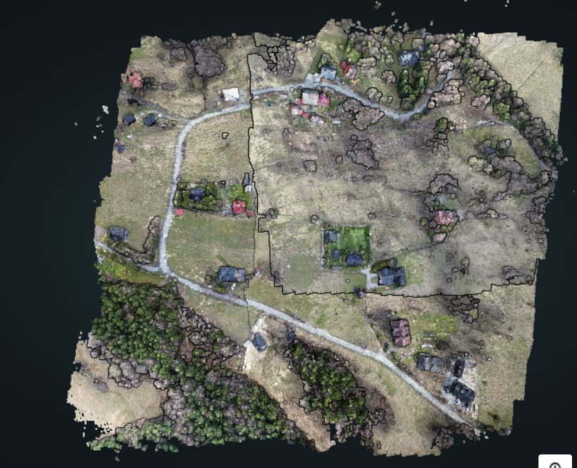
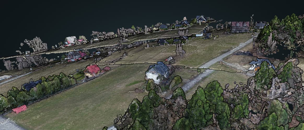
And the result looks like this:
Otrhophoto and DSM are also broken:
Each image groups is overlapping each other about 40%.
Why the result is so bad?
Try throwing the sm-no-align flag and maybe reduce your gps-accuracy down to 2x your expected ZDOP (if you know it).
I was not using sm-no-align, should I set it? I was thinking that setting it will disable aliigning submodels… But my submodels are not aligned anyway… I can try set gps-accuracy to about 40 (it looks that max distance between not aligned grounds is about 20m, so GPS vertical error is something abut 20m)
When I process datasets in seperate tasks, I see in QGIS that reported elelvation for the same point differs 17m for 2 separately generated dsm’s
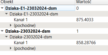
Each dataset was seperate flight, X/Y gps accuracy is decent good I thinks (quality reports says less than 1m), but elevation error for each flight is high…
EDIT:
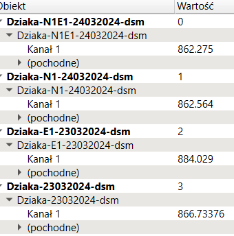
Reported elevation for other point, that is overlaped on each dataset/flight:
Maybe set sm-no-align to true and leave the gps-accuracy at 3m, and let us know how it goes. I have some suspicions the alignment isn’t working and needs some work.
I’ve tried once more with suggested parameters - sm-no-align: true and gps-accuracy: 3. Same result as before, new pointcloud:
All used options in WebODM:
cameras: {“dji fc3682 4000 3000 brown 0.6666”:{“projection_type”:“brown”,“width”:4000,“height”:3000,“focal_x”:0.7005682826935721,“focal_y”:0.7005682826935721,“c_x”:0.002590623154363632,“c_y”:0.0004340447550161649,“k1”:0.07668636352379475,“k2”:-0.1244619484681392,“p1”:0.002264327196130953,“p2”:0.0005966885906687318,“k3”:0.07867907585476787}}, dem-resolution: 2.0, dsm: true, gps-accuracy: 3, mesh-size: 300000, optimize-disk-space: true, orthophoto-resolution: 2.0, pc-quality: high, pc-sample: 0.01, rolling-shutter: true, rolling-shutter-readout: 26, sm-no-align: true, split: 1, split-overlap: 0
Have you looked at your Z values? They likely vary wildly. I assume these are multiple flights on different days.
Edit:
Also, if you can share the data, I might have time to take a look.
Yes, that was multiple flights, and I think it is normal that GPS reported altitude can vary for each flight - thats why barometer and atmospheric pressure at sea level are used to determine accurate altitude. But I don’t need accurate ground elevation level. Each segment is overlapping each other about 40% - ODM can’t normalize ground plane for 2 segments based on common detected features on overlaping images from each segment?
You can find all images here:
https://groch.cloud/misc/skawica_map-dzialka_cluster.zip
Let me give it a wack. Whether it will correct for wrong Z values depends on a few factors. Generally for non-split-merge processing, errors in Z are easily dealt with. Split-merge is more sensitive, unfortunately.
I’ll be re-writing split-merge this year. Would it be ok if I use this dataset as a test dataset? If so, would it be ok to license under CC BY-SA 4.0 Deed | Attribution-ShareAlike 4.0 International | Creative Commons?
If not, no problem. And thanks for sending your data along. I’ll give it some attempts.
Yes, you can use it as test dataset. I’m ok with suggested licensing.
Cool. Thanks for that!
Looking at it, I already have a guess at something you can try:
Try processing with defaults but without your orbits. I don’t think at your low altitude that there’s enough overlap to tie in the orbits successfully, and given the confounding problem of Z error, you’re getting multiple reconstructions. I’ll try a few things in the meantime, but that at least will help us discern the direction of a fix, if any.
I can try retry without orbits, but I don’t think that there was partial reconstructions. In log for each submodel I can see:
2024-04-04 14:23:44,575 INFO: Reconstruction 0: 205 images, 153211 points
2024-04-04 14:23:44,575 INFO: 1 partial reconstructions in total.
[INFO] Reconstructing D:\ODM\NodeODM\data\4a3125de-c1a9-4cce-88cb-a36a947d6e49\submodels\submodel_0001\opensfm
[INFO] running “D:\ODM\SuperBuild\install\bin\opensfm\bin\opensfm” create_tracks “D:\ODM\NodeODM\data\4a3125de-c1a9-4cce-88cb-a36a947d6e49\submodels\submodel_0001\opensfm”
2024-04-04 14:46:28,230 INFO: Reconstruction 0: 207 images, 148868 points
2024-04-04 14:46:28,230 INFO: 1 partial reconstructions in total.
[INFO] Reconstructing D:\ODM\NodeODM\data\4a3125de-c1a9-4cce-88cb-a36a947d6e49\submodels\submodel_0002\opensfm
[INFO] running “D:\ODM\SuperBuild\install\bin\opensfm\bin\opensfm” create_tracks “D:\ODM\NodeODM\data\4a3125de-c1a9-4cce-88cb-a36a947d6e49\submodels\submodel_0002\opensfm”
2024-04-04 15:10:51,818 INFO: Reconstruction 0: 204 images, 123143 points
2024-04-04 15:10:51,819 INFO: 1 partial reconstructions in total.
[INFO] Reconstructing D:\ODM\NodeODM\data\4a3125de-c1a9-4cce-88cb-a36a947d6e49\submodels\submodel_0003\opensfm
[INFO] running “D:\ODM\SuperBuild\install\bin\opensfm\bin\opensfm” create_tracks “D:\ODM\NodeODM\data\4a3125de-c1a9-4cce-88cb-a36a947d6e49\submodels\submodel_0003\opensfm”
I’ve tried without orbits - it gives me same result…
Also I’ve tried another set of data for other region. Also 4 flights, same result as before:
I can also share this dataset like before:
https://groch.cloud/misc/krywald_map-split.zip