My goal is to produce high quality and accurate orthos using a 16 core intel server with 96GB of ram. Projects are typically 800 or less 50mp images.
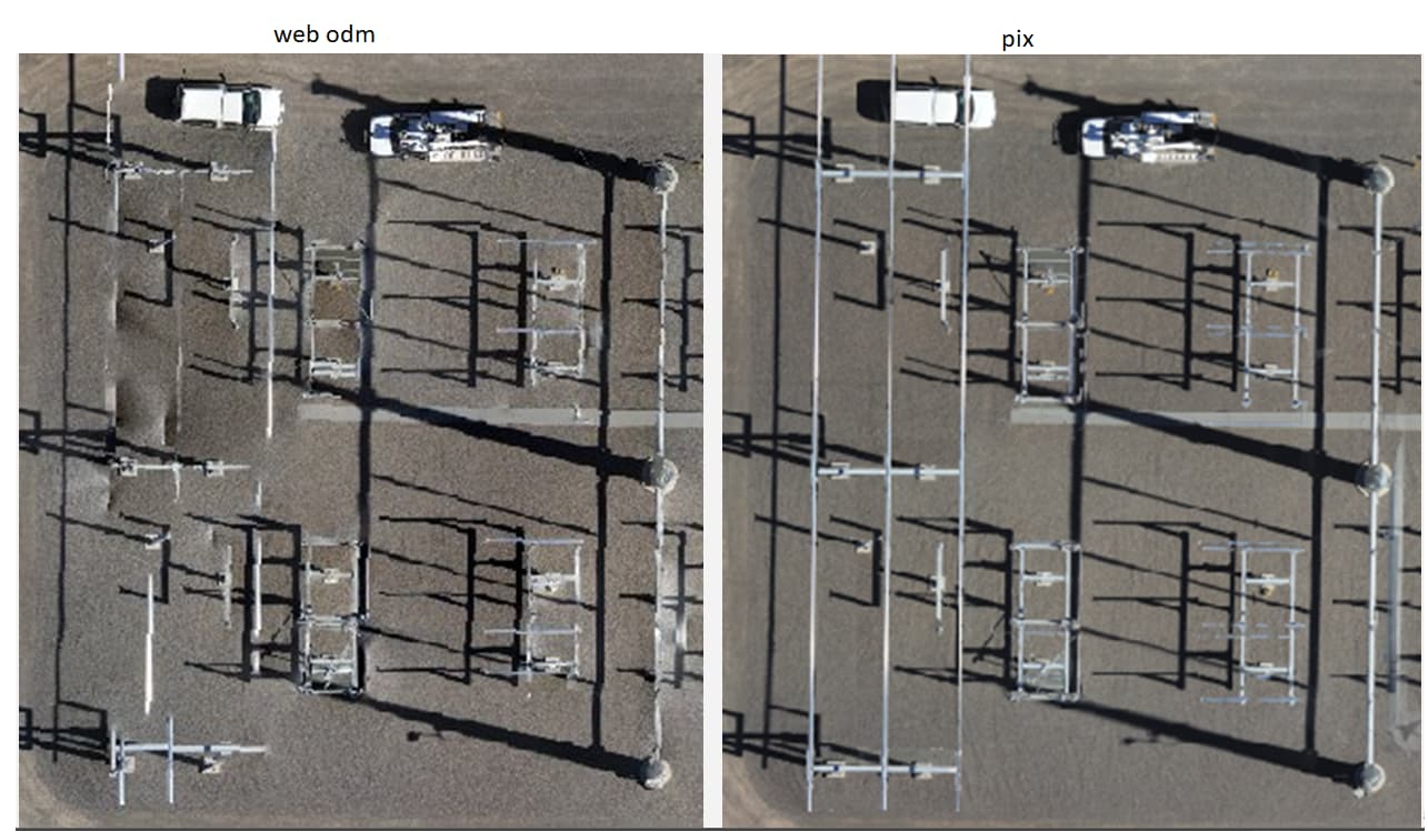
The webODM orthos that I’ve generated using the Skydio x10 are pretty rough when I compare the results to pix. Some features are just erased others don’t quite line up. I’m wondering if something related to this specific sensor (Skydio X10 VT300-L wide angle camera 50MP) is causing the issues.
I see similar results even if I tweak the overlap settings or fly at different altitudes. I’ve tried overlap between 75-90 and heights of 60-300 feet. This data set was flown nadir but I’ve also tried 10-20 degrees off nadir with similar results.
Processing settings I have been using: auto-boundary:true, dem-resolution:2.0, dsm:true, dtm:true, optimize-disk-space:true, orthophoto-resolution:1.0, pc-quality:ultra
Thanks for the help Saijin, I’ve exhausted all other options!
I processed this sample using Pix4d cloud with the default options. I just tried your recommendation using the fields preset and see the same distorted results. My flight planning software flies in the “lawn mower pattern” and the site has many similar features. Is that causing the distortion?
I haven’t tested a capture of the same site with elevated utility lines using another camera using the webodm engine. I’m open to manually characterizing the sensor if that will help. Just to clarify is this the process that involves taking photos of the checkerboard from multiple angles to correct for lens distortion?
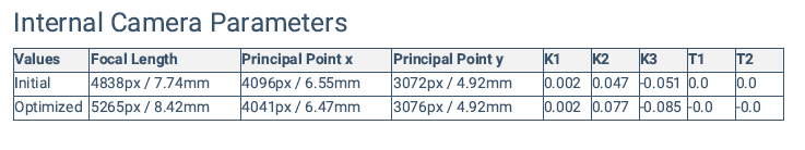
Sample image attached below. I’ve been trying with the brown lens type. From the output of a Pix project with this sensor I noticed this section containing camera parameters
I tried a similar capture yesterday using a different drone (Skydio S2+) and I’m getting pretty close to the same poor results. The Pix4d cloud engine appears to be better optimized for complex structures with cables and repetitive features. If I can find the time I’ll try processing the data set with MICMAC and see how the results compare.