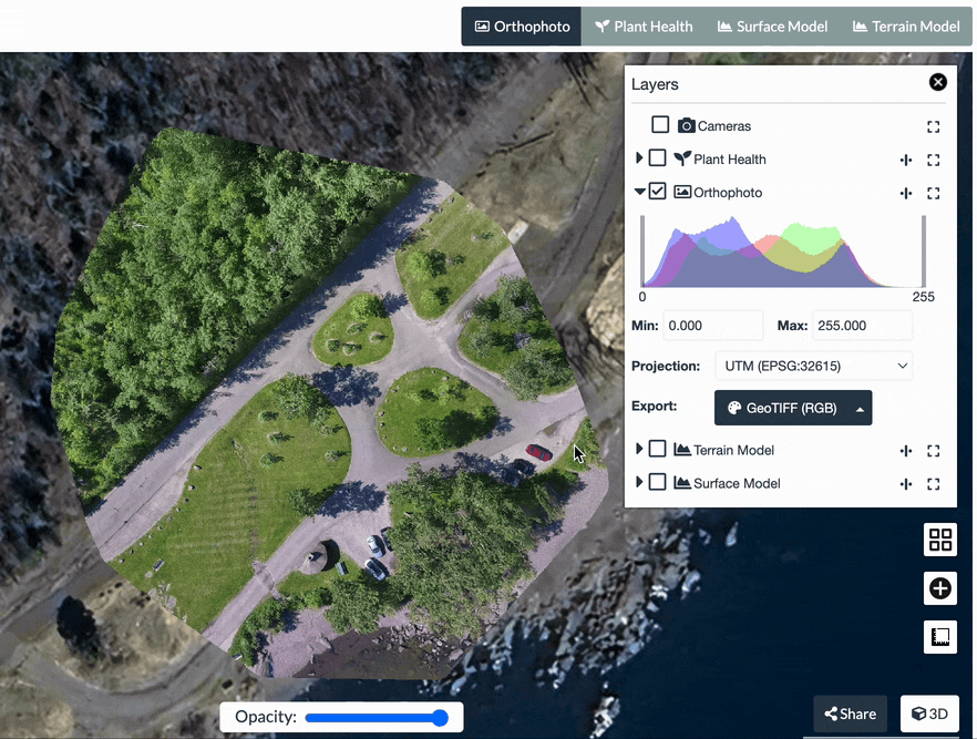
The ortho maps that WebODM creates are excellent. I also use the Mavic 3T. I’d love to be able to create a map using the RGB camera and then fly the exact same path but with the thermal camera and make an ortho with those images. Then overlay them with the swipe control down the middle and move it side to side to compare the maps.
This can be done using the DJI Flight Hub and is a pretty cool feature to have both for thermal imagery over RGB but also for comparing RBG pics to easily show progress at a construction site…
Is this not available in WebODM? Just want to make sure i’m not missing it.
Thanks
Harry
Yes, something like this would be an awesome feature! One of the main uses of mapping is to compare progress… most often at construction sites… so doing this is key!
having a 3rd app that is not web based, doesn’t really help… it needs to be integrated with this platform to provide the customer with a single source.
Thanks for your reply! I would love to contribute. For me this is new (I’m not a developer, I manage our dev projects) but I’m eager to learn. The least I can do is test functionality and give feedback.
In my team I have two senior developers who actually can do something useful so that gives some perspective.
However, for the next 1-2 months they are pretty busy with coding functionalities for our own platform but maybe this time is good to lay out a roadmap / planning and funding.
Note to self
Let me start by asking two questions in my own network:
my devs → Can we make this? And how many hours should this take?
my network → Would you like to contribute with (some) funding?
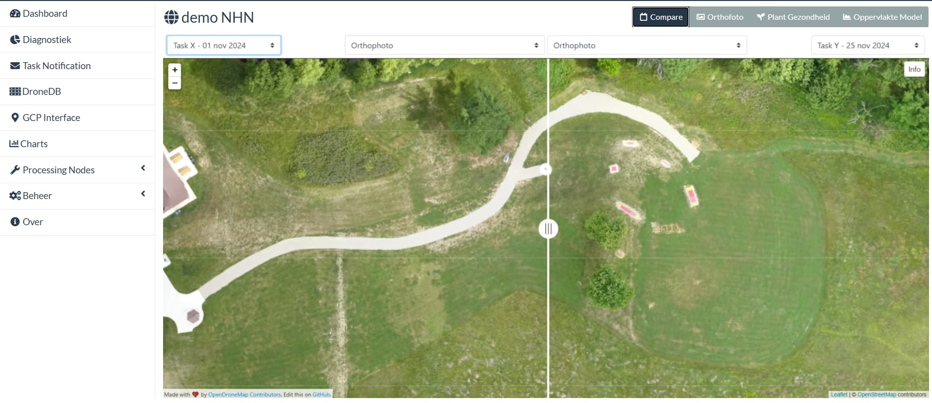
Glad to hear there’s interest in this feature, I’ve recently started a proof of concept work in this area, there are still several quirks to fix and haven’t finished due to other commitments, but would love to fast-track this.
Preview (click to animate):
This will allow to compare orthophotos and other assets between tasks belonging to the same project and within the same task.
I’ll make sure I’ll forward your screen / funding proposal to my network.
Three quick questions:
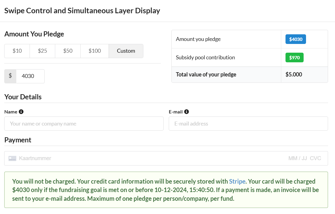
Does this proposal end after 12 days? I’m currently asking in my network (already 2 organisations who are very interested) but 12 days might be a bit short for the organisations to get approval. I have to make a quote and invoice for them to receive payments/funding.
Is there another way to make sure the payment reaches you / WebODM? For me (my company) it would be easier to work (justify) via a quote and invoice.
For me the idea of pledging funds is new. Am I correct to assume that if 4030 dollar is ‘collected’ the ‘other’ 970 dollar will be added to the the pledge (making the requested 5000 dollar?)
Yes, although there’s some flexibility here and we could extend the deadline if it means getting this funded.
I can certainly send you a formal quote; just get in touch via Contact - UAV4GEO providing company name, address, etc and pledge amount. Once the quote is approved I can just register it along with the pledges in the system.
Yes. See the “How it works” page on the quadratik page for details of how exactly that’s calculated.
this solution shown here is exactly what I’m looking for and would be an awesome addition the ODM toolkit. It would make for a great tool for comparing RGB images to thermal imagery of the same area. Excellent for roof inspection and wetlands delineation.
I went back and looked at this… is this splitter control still in the works? I contributed to the funding but it didn’t get approved. What else needs to be done on this, this is exactly what I was looking for!