Facade rendering test with new Engine

Hi guys, I don’t normally bother for help, but I’m stuck!! :sob:

What I’m trying to do is a simple facade rendering test and the data, including images, is in the folder of the link below.

Data folder link
https://drive.google.com/drive/folders/1fQysQRy1hyX3Dw_6uCGPhNH_lv_eE8gY?usp=sharing

and my question is it looked way better before I updated the ODM new enginie, it was almost perfect with the default setting, but now with the newly updated engine, I don’t think I can make it any better without help.

The result data in the folder was processed with the following parameters by the way.

=============================================================================
auto-boundary: true, crop: 0, debug: true, dem-gapfill-steps: 4, dem-resolution: 1, depthmap-resolution: 2048, feature-quality: ultra, gps-accuracy: 1, mesh-size: 300000, min-num-features: 64000, orthophoto-resolution: 1, pc-classify: true, pc-filter: 0, pc-geometric: true, pc-quality: ultra, pc-sample: 0.001, resize-to: -1, use-3dmesh: true, verbose: true

and the camera positions look like this.


Processed on the chrome and my system set up is,

Windows 10 - WSL2 - DOCKER desktop - WebODM

within the past 2 days, I’ve tried with different settings of the parameters and I keep getting almost no usable result. It would be appreciated if anyone can guide me. :pray:

1 Like

There is a huge amount of background and sky in some of the images, which makes it a bit tricky, here is my attempt using a boundary file

[Hanam Union Park - 12/06/2022](javascript:void(0):wink:
69 00:33:10
|Options:|boundary: {“type”:“FeatureCollection”,“features”:[{“type”:“Feature”,“properties”:{},“geometry”:{“type”:“Polygon”,“coordinates”:[[[127.2206711769104,37.54769069847353],[127.22036004066466,37.54766092635254],[127.22017765045166,37.54737596402145],[127.22018837928772,37.54709100060095],[127.22044587135314,37.54687408741636],[127.22091257572174,37.546640160725566],[127.2214597463608,37.54672097184719],[127.22159922122955,37.54697191108756],[127.22125589847566,37.54755459725194],[127.2206711769104,37.54769069847353]]]}}]}, depthmap-resolution: 1280, feature-quality: ultra, gps-accuracy: 6, mesh-octree-depth: 12, mesh-size: 250000, orthophoto-resolution: 0.5, pc-quality: high, resize-to: -1, use-3dmesh: true, rerun-from: opensfm|
|Average GSD:|2.08 cm|
|Area:|1,479.23 m²|
|Reconstructed Points:|1,000,588|

2 Likes

In your survey design, you should increase overlap/sidelap a fair bit more, as well. it will make reconstruction much better, and much easier.

1 Like

Wow… this is so cool!! and this is jaw-dropping information for me, and thank you so much for the reply Gordon. :pray::+1: and you are so generous to share your tips of years of experience. I will try to figure out the GEOJSON part as well. The idea you pointed out helped real big. :raised_hands:

2 Likes

Saijin_Naib, you are like the Genie😀 in this community, and increasing the value of both changed a lot for the result. still need to work on the detail more but looks dramatically great already now.

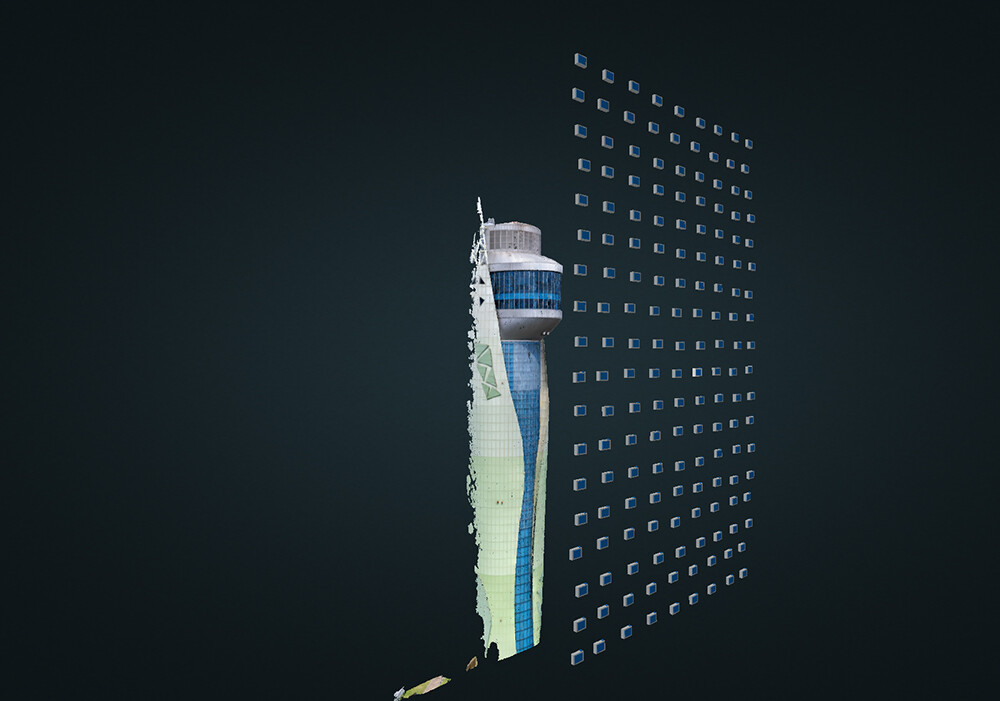
They were 75 / 75 % each and changed to 85 / 85 % and the result looks like this.


Again, thank you so much for the tip. :pray::+1:

3 Likes

Any time!

That’s a beautiful reconstruction! Very well done!

These are harder to implement but if your subjects are going to be shiny buildings:
An evenly-overcast day is best (no harsh highlights and shadows!) if you can choose when to collect

Investigate if your platform can have a circular polarizer filter fitted on the camera without harming the gimbal. These will (when tuned properly) cut a huge amount of bouncing light in the scene, reducing or eliminating reflections and boosting overall contrast/saturation a bit (do note that they reduce incoming light a bit, so ISO and shutter speed might go up a fractional amount to compensate).

2 Likes

This topic was automatically closed 30 days after the last reply. New replies are no longer allowed.